What is Online Mapping? What are Web Maps?
Online mapping, otherwise known as web mapping or web GIS, is the process of using the internet to view, analyze, or share a web map. A web map is created by converting (geospatial) data to an interactive display of geographic content with web mapping software such as ArcGIS Online. Web maps are full of geographic information that can be divided into organized layers. They can be displayed over the phone, computer or any device that connects to the internet. Web maps are also simple to make, believe it or not.
Online mapping is important and provides us with the ability to visualize geospatial data on the internet through a web browser. It is also important to many organizations because it provides the ability to distribute critical information to everyone, everywhere, and at any time.

Source. Example of a web map on a computer screen.
There are many ways to do this. ArcGIS online and Mapbox are just a few examples of web mapping tools that you can use to create a web map. FME, on the other hand, can process data to send to web maps or even stream it.
We interact with web maps every day. Web mapping is a very accessible way of interacting with location data. Most of us are doing it without realizing it! from spatial analysis to simply finding out where the closest supermarket or restaurant is.
Rasterization for Web Mapping Platforms
Raster data is pixelated (or gridded) data. Each pixel is associated with a specific geographical location. Each pixel used is a record of data, which may have multiple channels to record even more information about each pixel. There are many ways to use raster data. However, let’s focus on how to rasterize for web mapping platforms.
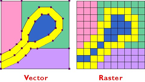
The difference between vector and raster data. The edges of the vector polygons become entire cells when converted to raster.
Rasterization is the process of converting vector data into a raster tile. This raster data that can be displayed on any device. You can use FME for rasterization.
To rasterize data, you need to source vector data. You can use FME and its transformers to rasterize the vector data. Once vector data has been transformed to raster data FME can be used to create web map tiles using the WebMapTiler.
It is really easy to start making raster tiles with FME. Only FME Desktop is needed to start making them. The results of the tiling process are not limited to a single mapping platform. It can also be used with Google Earth and other web mapping platforms.
FME Server allows you to automate the creation of web map tiles too. FME Server can be used to increase performance if the workspace is divided into multiple jobs. For a more detailed guide on how to rasterize data using FME, here is an article for you!
How to Distribute Data with Web Maps
The distribution of (use) data is simply taking data and sharing it with others. Data distribution can improve data availability. Data distribution can also alleviate other issues related to servers and slow network access. There are several ways to distribute your data. You can even distribute data with web maps using FME so your organization can function more efficiently and make more use of your data!
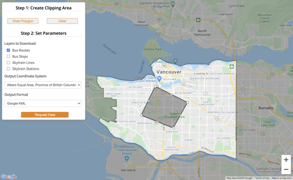
This example demonstrates the FME Server Data Download service can integrate with web maps such as Google Maps and ArcGIS Server.
The above application demonstrates FME Servers Data Download service and how it can integrate web maps such as Google Maps and ArcGIS Server. This application provides an interface for users to select a study area by drawing a polygon. Once the polygon is drawn, the user can continue building up a request by selecting the layers they wish to download and the format and the coordinate system of the returned data.
The request is then sent to FME Server which processes it and returns the data to the user. Click here for a step-by-step guide on how to distribute data using FME.
Figuring Out Online Mapping
I hope this article makes Online Mapping, Web Mapping or Web GIS a little clearer to you. If you have any questions, don’t be afraid to comment below. To sign off, here is an article that focuses on other FME tips that could be useful for when you rasterize data or are online mapping.

Nicole Lee