Imagine: it is a busy day at City Hall with the telephone ringing every two minutes. Citizens of the community are calling to report an issue in their neighbourhood. Some have been on hold for thirty minutes and are ready to hang up. If only there were unlimited staff to respond to every issue and keep a record.
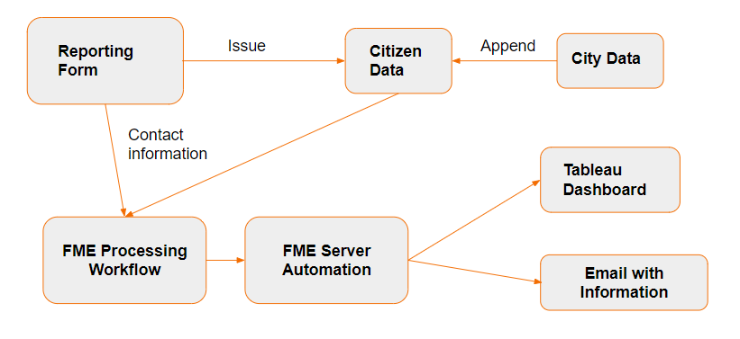
There is a simpler solution. Using FME, you can integrate an online citizen reporting form with business intelligence tools (BI) to automatically track requests as they come in. Business Intelligence tools are useful for quickly creating reports for large quantities of data and sharing them publicly. They also create a quick and easy way to visualize trends. With FME, the collected data can be processed and updated automatically.
FME Desktop supports 450+ formats and applications to help you integrate and transform data exactly for your needs. With a large volume of requests coming in, it’s hard to work through all of that data, but with FME, you can create complex pre-processing workflows and automate them to do all of the work. As a result, you can let it run in the background and focus on other important work. No phone call interruptions.
We’ll be using our Lost and Found Pets Reporting demo as an example.
Step 1: Create a report form
The first step is to create a reporting form using an app such as Esri ArcGIS Survey123. You can also use your favourite web application or HTML. Make the reporting form publicly available so anyone can submit a request.
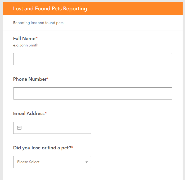
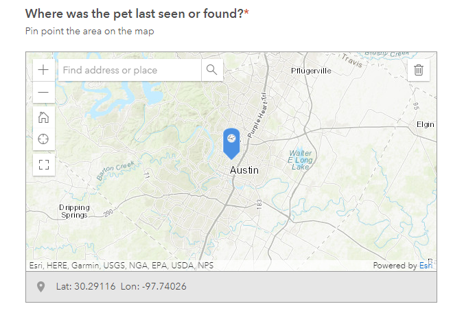
Our Lost and Found Pets form uses a map to get pet locations.
Step 2: Process the citizen report data
The data for this report, such as contact information, might need some work before it can be sent to other systems. FME can be used to process this data and push it to the applications you need. Depending on the reporting input, you might also want to filter the data and process it.
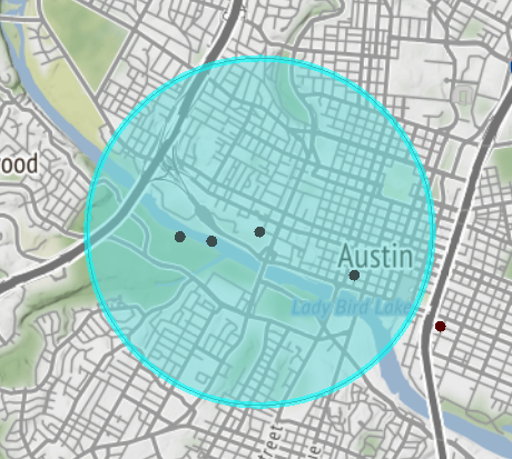
In our demo, we appended shelter and matched pets information to the citizen’s collected data. We did this by screening the lost pet and attaching any found pets features that were inside the radius.
Step 3: Respond to the citizens with an email
To save more time, responses to citizens can be automated. For this we use a combination of a workspace and an automation in FME Server. A webhook trigger can be added to your automation, so when a report form is completed, the workspace will run and send an email to the citizen.
In our demo, the email contains information on found pets that might match the lost pet, including their species, breed, color, and a photograph, as well as information on nearby animal shelters.
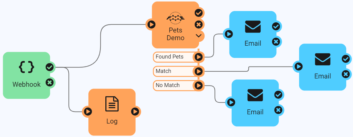
Step 4: Display data on a Business Intelligence dashboard
The data collected is difficult to interpret when it is read from a list. Business intelligence tools let you visualize data in a number of ways, such as graphs and maps, for better analysis. Citizen reports can improve cities by identifying areas that need work and then tracking progress.
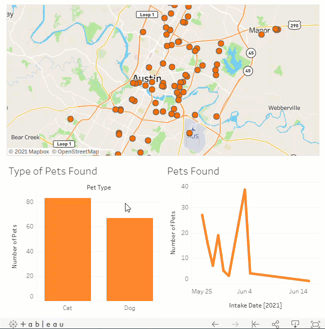
Using Tableau Public, we created a dashboard to show the number of found pets around Austin. From this data, we can track progress on finding lost pets or reducing the number of strays.
Get Started with an Automated Citizen Reporting App
With FME, you can connect to citizen’s submission data, transform it to fit your needs, and join it from various sources. You can save time by automating the workflow to send response emails and write data to a central database. A Business Intelligence tool can be used to analyze and visualize data, letting you measure success and improve processes. Now, you have time to create more workflows in other areas using FME.
For a step-by-step overview of this project, including the workspace, visit the tutorial Local Government Citizen Services and BI Reporting.
Learn more:
- 8 Ways Local Governments Can Improve Operations Using Data Integration
- Lost and Found Pets Demo: Local Government Citizen Services and BI Reporting Application
- Interactive FME Demos
- Tortoises & Tesseracts: ETL for BI Data Warehousing

Martina Todorova
Martina Todorova graduated in 2020 from Simon Fraser University with a B.A. in Geography and a minor in Sociology. Throughout her B.A., she took urban and human geography courses that taught her about urban planning, policies, and transportation. Currently, as a BCIT GIS student, Martina would like to focus on solving problems around transportation and municipal or urban planning. She is also drawn to exploring web-based GIS resources.